


MissMoxy
'svbeesgal'
- Joined
- Mar 6, 2008
- Location
- nearer the water
- Moto(s)
- Stuff of stories: F800st, Vstrom650, sv650s, Dr350, SuperTenere
- Name
- Nibor
I found out four days before Thanksgiving week that I would have the week off without burning alot of leave. I decided that I would head over to Lake Isabella and see if I could accomplish Southern California Mad Map loop 9,10,11 and 12. I called the KOA campground and they reported 75 degrees during the day with 55 at night and, as the person recalled, the roads around the area were not closed as far as any inclement weather. A few days before the trip...which I planned to be around a thousand miles, I decided I would head to L.A. to see my cousin. Saturday I last minute had my front tire changed and my rear tire I confidently left on with 8k miles on it.

Sunday the 23rd I headed out at 7:30am. My mom said a tearful goodbye at made me promise I wouldn't go past 72 mph and not drive after dark
 . I traveled South on 680, East on 580 and hit highway 5. Highway 5 was B O R I N G.....there weren't alot of gas stops and the scenery was bland. Bad enough that you can see w a a a y down the freeway of where you'll be in 10 minutes. For amusement my eyes zoned in and out of the flies that were now piling up on my face shield. Passing through Coalinga I smelled the stench of cows...then the fly matter began to pile up.... I neared Tejon pass and could hardly make out the San Emigdio mountains in the thick haze. Traveling through the pass was a welcomed sight. Traffic became thicker as I headed south on I 5. Descending the grade the haze became worse and traffic just about choking. I counted 2 other motorcycles....CrAzY to ride in this stuff !! I was traveling the Eastern side of Mad Map Loop #6 and still haven't found why that Eastern side is highlighted yelllow......I took 405 to 101 West and arrived in Topanga at 3:30 where I would be spending the next couple of nights (originally only 1 night was planned but they convinced me to stay another).
24th. Monday We took the kids to school, the commute traffic subsided and I was off to explore mad map recommendation number 7. I headed up windy Fernwood Pacific Drive that ambled down the backside. The views of L.A. were ....eh....ok.

I took a left onto Mullholland and travelled up , then down Kanan Dume Road- nice, windy good-condition road that lead to Hwy 1 .Gas was not that easy to find. I gassed up and planned to head North on 1 to hit Deer Creek road, which, I had to keep an eye peeled for the turn off because at that point I was traveling in the boonies where the road was two lanes and no houses.
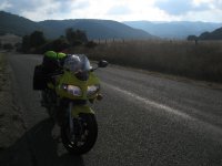
The ascent was breathtaking and the scenery exciting (stemming from Hwy 5 drudgery). Houses hugged and dotted the surrounding hillside.

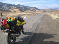
The road changed names to Yerba Beuena and so did the road conditions. No houses were out here. This road I felt every jarring piece of gravel under my tires...reminiscent of Mines where the lose gravel bits blend in with the pavement cracks and sags. The road narrowed and blended into the roadside shrubs.... I felt truely alone ...

The rest of the road was littered with houses and as equally windy...but nothing much I felt to take pictures of.... I wound my way back up the hillside towards my cousines and took a sharp U turn that lead me back down towards hwy One on Las Flores Road. This road had hairpin turns and gave a view out onto the brushy hillside as I passed houses and cars coming up the canyon. Definately not the road to take when needing to rush into town.
Sunday the 23rd I headed out at 7:30am. My mom said a tearful goodbye at made me promise I wouldn't go past 72 mph
and not drive after dark. I traveled South on 680, East on 580 and hit highway 5. Highway 5 was B O R I N G.....there weren't alot of gas stops and the scenery was bland. Bad enough that you can see w a a a y down the freeway of where you'll be in 10 minutes. For amusement my eyes zoned in and out of the flies that were now piling up on my face shield. Passing through Coalinga I smelled the stench of cows...then the fly matter began to pile up.... I neared Tejon pass and could hardly make out the San Emigdio mountains in the thick haze. Traveling through the pass was a welcomed sight. Traffic became thicker as I headed south on I 5. Descending the grade the haze became worse and traffic just about choking. I counted 2 other motorcycles....CrAzY to ride in this stuff !! I was traveling the Eastern side of Mad Map Loop #6 and still haven't found why that Eastern side is highlighted yelllow......I took 405 to 101 West and arrived in Topanga at 3:30 where I would be spending the next couple of nights (originally only 1 night was planned but they convinced me to stay another).24th. Monday We took the kids to school, the commute traffic subsided and I was off to explore mad map recommendation number 7. I headed up windy Fernwood Pacific Drive that ambled down the backside. The views of L.A. were ....eh....ok.
I took a left onto Mullholland and travelled up , then down Kanan Dume Road- nice, windy good-condition road that lead to Hwy 1 .Gas was not that easy to find. I gassed up and planned to head North on 1 to hit Deer Creek road, which, I had to keep an eye peeled for the turn off because at that point I was traveling in the boonies where the road was two lanes and no houses.
The ascent was breathtaking and the scenery exciting (stemming from Hwy 5 drudgery). Houses hugged and dotted the surrounding hillside.
The road changed names to Yerba Beuena and so did the road conditions. No houses were out here. This road I felt every jarring piece of gravel under my tires...reminiscent of Mines where the lose gravel bits blend in with the pavement cracks and sags. The road narrowed and blended into the roadside shrubs.... I felt truely alone ...
The rest of the road was littered with houses and as equally windy...but nothing much I felt to take pictures of.... I wound my way back up the hillside towards my cousines and took a sharp U turn that lead me back down towards hwy One on Las Flores Road. This road had hairpin turns and gave a view out onto the brushy hillside as I passed houses and cars coming up the canyon. Definately not the road to take when needing to rush into town.
Attachments

Last edited:






 and
and 

