• There has been a recent cluster of spammers accessing BARFer accounts and posting spam. To safeguard your account, please consider changing your password. It would be even better to take the additional step of enabling 2 Factor Authentication (2FA) on your BARF account. Read more here.

ADV/DS ride Lake Berryessa/Knoxville OHV/Rayhouse Rd.

120 miles of dirt or is that counting pavement? Either way, it sounds like a long day!

It was 110 miles of dirt and about 10 miles of pavement.
Had a great time.:thumbup

I have it mapped out GPS tracks if anyone wants a copy.
 
Last edited:
I'm green with this, but added your file under the "GPX" folder on the device (eTrex20). When I did that, a new option appeared (Routes) under "Where To?" in the device menu. When I click on that, there are three selections, all named "Routes". When I click on any of them, the device looks like it tries to load, but just hangs. I rebooted after a few minutes. To be fair, I've tried the elsewhere.org gpsvisualizer directions and can't create a gpx file that the device will recognize. Elsewhere.org just says "loading..." endlessly in firefox and gpsvisualiser's gpx conversion of the kml files aren't recognized, so I can't confirm functionality with a known good gpx file.

 
All you need to do is download and then open it in your own software that will either load it or convert it to yours. It's a GPX file.
 
I found the problem. It's downloading as an xml file. Change the ext to gpx then it should work
 
Im stupid, it downloaded but cant open it.. my email is ,dgaya73@gmail.com.
Thank you
Email sent, let me know if anyone else wants any of my GPX files. I wish there was a place/way that I could upload them for all to share. I can't seem to get Google Drive to do it right. Any ideas??
Thanks.
 
All you need to do is download and then open it in your own software that will either load it or convert it to yours. It's a GPX file.

I found the problem. It's downloading as an xml file. Change the ext to gpx then it should work

I don't have any GPS software installed and was trying the manual methods of creating a gpx file from Google Maps, but not having any luck. Yours downloaded as a gpx for me, not an xml. Anyway, I'm downloading Basecamp now and will see how it does importing the file.
 
About to do a short version of this ride if anyone wants to tag along or meet up somewhere along the way let me know...leaving in 30 min. Thinking Pleasants Valley, 128, 121, wooden valley and whatever in the middle to connect those...running the loop east or west...no preference. If I don't hear from anyone I will start on pleasants valley in vacaville and head up to 128 and then west and back down to fairfield.
 
If my crash bars show up in time, I'll attempt to do this ride. It was way too long since my last one
 
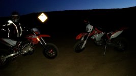
I need my head examined...me and a buddy decided to take our supermotos up there and didn't even leave Vacaville until around 4:30. Neither of us have over-sized gas tanks and we decided to do some exploring. We got gas in lower lake and then did Reif road to the 4-way intersection up on the ridge and hung a right to explore down that road. We did a total of 22 miles from the time we turned onto Reif until the time we were back on pavement. His bike ran out of gas 2 miles before the Chevron in Winters...lol. I was able to wedge my foot onto his rear axle slider and push his bike using my bike to make it to the gas station.
 
His bike ran out of gas 2 miles before the Chevron in Winters...lol. I was able to wedge my foot onto his rear axle slider and push his bike using my bike to make it to the gas station.

Now that is getting it done... Glad you made it back safely..
 
Might have been a little dark when we made it back to the 4-way intersection on the ridge!

I'll post some more later.
 

Attachments

  • 20140622_211511.jpg
    20140622_211511.jpg
    109.8 KB · Views: 59
Sounds like a fun day. It's boring when all goes according to plan. :laughing
 
Last edited:
Back
Top