• There has been a recent cluster of spammers accessing BARFer accounts and posting spam. To safeguard your account, please consider changing your password. It would be even better to take the additional step of enabling 2 Factor Authentication (2FA) on your BARF account. Read more here.

California Moto Roads - All Of Them

^^:thumbup
thanks for the heads-up about Merced Falls Rd repaving! :ride

here's a random road, getting ready to head up towards Gold Lake Hwy next weekend with my fishing pole, on my way to the BARF Hoho Midsummer Magic Weaverville Rally the following weekend:

picture.php


Butcher Ranch Road, Sierra City to Gold Lake Campground, unpaved. Google Map.

Updated in the OP.
 
Last edited:
^^:thumbup
thanks for the heads-up about Merced Falls Rd repaving! :ride

here's a random road, getting ready to head up towards Gold Lake Hwy next weekend with my fishing pole, on my way to the BARF Hoho Midsummer Magic Weaverville Rally the following weekend:

picture.php


Butcher Ranch Road, Sierra City to Gold Lake Campground, unpaved. Google Map.

Updated in the OP.


:thumbup Just came past there Tuesday on the return from my trip up north.
 
Paving is complete on Merced Falls road. Still a little green, and no lines yet, but very ridable.

Just back, 7/26. Road repaved, and new yellow lines. Ready to ride.
 
Last edited:
Baldhills Road between Weitchpec and Orick. Pavement is absolutely excellent from Weitchpec to near the summit where it briefly turns to gravel before entering the back side of Redwood National Park. The pavement within the park is kinda meh but that climb out of Weitchpec will not be forgotten I guarantee it

I recommend going West
Google Maps
 

Attachments

  • Capture.JPG
    Capture.JPG
    88.2 KB · Views: 4
Agreed. The west side pavement is very choppy and bumpy, but the east side, beyond the dirt section is very good. It's not a bad ride going DOWN the east side either, but it's definitely 'funner' to go up.
There is also a Native American Veterans facility/memorial on the east side that I have been meaning to visit.
 
Baldhills Road between Weitchpec and Orick. Pavement is absolutely excellent from Weitchpec to near the summit where it briefly turns to gravel before entering the back side of Redwood National Park. The pavement within the park is kinda meh but that climb out of Weitchpec will not be forgotten I guarantee it

I recommend going West
Google Maps

Thank you! A flagger told us about this road when we were riding 96 back in May. I've been wanting to check it out. :ride
 
Mormon Emigrant Trail, Sly Park to Shot Rock Vista Overlook. google map link. paved.

picture.php


idk, this might be a repost. awesome road. did it about a month ago, to get from a StonyBARF to the BARF rally in Hawthorne, NV. :ride
 
Bald Hills Road, Its paved all the way now. There used to be some Gravel. From Hoopa go 96 to Weitchpec, then 169 to Bald Hills Road.
It's a fun road that has lots of elevation change, and some sections that are out in the middle of nowhere. Beautiful vistas. On the eastern side there is the Yurok Tribe Veterans Cemetery that's worth a look if you make the time.
Thanks for the reminder wheels.
 
It's a fun road that has lots of elevation change, and some sections that are out in the middle of nowhere. Beautiful vistas. On the eastern side there is the Yurok Tribe Veterans Cemetery that's worth a look if you make the time.
Thanks for the reminder wheels.
i actually sent a friend through that way today on four wheels and mentioned the cemetary to him. i haven't heard back. it's been fully paved since last summer. i rode it in october of last year with the roomie and we say not one but TWO mama bears at different times and each had two cubs. i have seen so many bears in norcal that it's ridiculous.
 
Way ahead of ya...

Here's my big list of good riding roads, with the goal of listing everything paved and twisty not only in California, but the whole US

RoadRatings.com
 
Unless you're on a Dual Sport, Platina Road sucks. Marginal pavement at best, bumps galore and Mordor temperatures in the summer. I live in Shasta County, 9 miles from Lassen Volcanic Park right on Hwy 44 ( which is very nice although not super challenging), and there are some short but fun roads up here such as Black Butte, Wildcat and Wilson Hill. The road through Lassen Park is amazing, the views spectacular, although the speed limit is low. However there's usually only one park ranger patrolling. It's Hwy 89. Weekdays are best.

Mad
 
Way ahead of ya...

Here's my big list of good riding roads, with the goal of listing everything paved and twisty not only in California, but the whole US

RoadRatings.com
I appreciate how RoadRatings.com redirects to a spreadsheet, and a good spreadsheet at that. Well done. Characterizing routes by appropriate bike type is super helpful, thank you!
 
I appreciate how RoadRatings.com redirects to a spreadsheet, and a good spreadsheet at that. Well done. Characterizing routes by appropriate bike type is super helpful, thank you!
Thank you! I'd like add a site/app with a visual map overlay of the roads. I have it all planned and laid out, just need someone to wiggle their fingers and make it a reality. If you know any coders who would be open to helping build it, please let me know. Compensation by equity or riding lessons.
 
Using Google Maps, it is not ideal but possible and free. This is a very quickly done example. Are you comfortable editing XML? Map tools use KML format for overlays, and is essentially the same as XML. I can't attach a KML file but will show the contents below. If you want to use AI (like chatgpt), you can export the spreadsheet to a CSV file, upload it, and ask it to format a KML file however you want. Then make your way to 
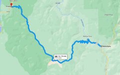
https://www.google.com/mymaps, click "Create a New Map", and then import the KML file in a new layer. In this example, google Maps should not show the direct line (as it is in the image) but follow the route, but a direct line is what it shows. With the description overlay, it looks like this:


Screenshot 2025-08-02 at 9.01.41 PM.png

Hoping others have ideas on how to make this look better. You should be able to import all your routes and descriptions through one KML file and iterate on how you want to improve it, including adding more latitude/longitude entries so the line matches better to the actual route. You can also color code each route, then click around to show one description at a time.

Here is the contents of the KML file used, and it is done with one row of your data, unedited:

<?xml version="1.0" ?>
<kml xmlns="http://www.opengis.net/kml/2.2">
<Document>
<Placemark>
<name>CA 175 (Middletown to Kelseyville)</name>
<description>&lt;b&gt;Region:&lt;/b&gt; Bay Area – Clear Lake&lt;br&gt;
&lt;b&gt;Distance:&lt;/b&gt; 20 miles&lt;br&gt;
&lt;b&gt;Surface:&lt;/b&gt; Fully paved&lt;br&gt;
&lt;b&gt;Bike Types:&lt;/b&gt; Sport&lt;br&gt;
&lt;b&gt;Rating:&lt;/b&gt; 9.5&lt;br&gt;
&lt;b&gt;Fun:&lt;/b&gt; 10 | &lt;b&gt;Condition:&lt;/b&gt; 10 | &lt;b&gt;Debris:&lt;/b&gt; 9 | &lt;b&gt;Traffic:&lt;/b&gt; 9&lt;br&gt;
&lt;b&gt;Bike Used:&lt;/b&gt; Sport on Sun, 05/10/20&lt;br&gt;
&lt;b&gt;Notes:&lt;/b&gt; Superb road with smooth pavement, lovely undulations, and a nice variety of turns, most of which are medium in size.&lt;br&gt;
&lt;a href=&quot;https://www.google.com/maps/dir/38.7524206,-122.6153787/38.9423513,-122.7922068&quot;&gt;Google Maps Route&lt;/a&gt;</description>
<LineString>
<tessellate>1</tessellate>
<coordinates>-122.6153787,38.7524206,0 -122.7922068,38.9423513,0</coordinates>
</LineString>
</Placemark>
</Document>
</kml>

Hope it helps!
 
Back
Top