• There has been a recent cluster of spammers accessing BARFer accounts and posting spam. To safeguard your account, please consider changing your password. It would be even better to take the additional step of enabling 2 Factor Authentication (2FA) on your BARF account. Read more here.

Hwy 58 to Hwy 166?

fbenz

2wheeladventurer
Joined
Sep 26, 2006
Location
San Rafael
Moto(s)
'17 1200 GS Rallye, HP2 Enduro, '10 KTM 450 EXC, DR650, WeeStrom, R100GS
I'm planning a ride with my nephew in Mid April and trying to figure out how I can get from Hwy 58 (east of Paso Robles, where we'll be starting the day) to Hwy 166. Specifically is there any way connect 58 south to 166 and then make my way even further south after crossing 166. Would like to end up somewhere that night off of 101 somewhere between Santa Ynez and Santa Maria before heading up the coast the next day.

Looks like Pozo road might be an option and further south (of 166) have found Tepusquet Road to Foxen Canyon Road, but have never ridden the area and so looking for advice.

We'll be on large dual sports... a 1200 GS and a V-Strom 650 and so can't do anything too challenging. Hoping for a mix of pavement and mild dirt/gravel. Any tips, advice, suggestions or tracks would be much appreciated.
 
If I remember correctly, you can take Soda Rd (soda springs? Soda Lake? Soda Creek?) Soda something, all the way through the Carrizo and you'll bypass all the boring, oil, parts of 58 and 33. And it's partly paved, partly hard pack. I've never ridden Tepusquet or Foxen, but I've heard it's all paved, but super goaty and chunked up. So perfect for your big bikes or a supermoto! I'm sure others will chime in with better routes.
 
Pozo road was closed a few years back due to several landslides and washouts. I’d make sure it’s open.
 
think it’s Soda Lake Road and Elkhorn Road through Carrizo Plain NM to get from Hwy 58 south to Hwy 166. I assumed he’s looking for roads that were not so far east, when talking about getting back to Tepusquet and Foxen, at which point I had nothing. :laughing
 
Tepusquet and Foxen are true riding jewels. In fact, they'll probably be the best roads you ride on the trip.
I hella loved Foxen when I was on it last week. Not at all technical but nice curves and a lot of the pavement is in excellent condition.
 
think it’s Soda Lake Road and Elkhorn Road through Carrizo Plain NM to get from Hwy 58 south to Hwy 166. I assumed he’s looking for roads that were not so far east, when talking about getting back to Tepusquet and Foxen, at which point I had nothing. :laughing
Elkhorn is pretty rutty and a lot for a big GS and a wee storm. Strong bodies will be by ok.
 
Huge THANKS!!!! to everyone for the suggestions/advice. Really appreciate it.

From everyone's comments, a plan is coming together.

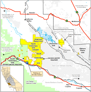
Curious, no mention of Sprague HIll Rd. (off of Soda Lake Road just short of Soda Lake) to Chimeneas Ranch Rd (thru Carrizo Canyon) down to 166? Is that an option?
 
Is that an option?
I have not ventured off Soda Lake Rd, but from what I can find, option described would pass over Carrizo Plains Ecological Reserve requiring permit for access. It's unclear if they'd allow ride through. 🤷‍♂️

From Paso Robles, I've reached CA-166 via Soda Lake Rd and via CA-58 → CA-33 (stopping for lunch and gas in Taft).
 
ime, such as it is, everything heading west out of Carrizo Plain is a dead end or gated.

I'd be thrilled if there were a way to access fire roads heading west out of Carrizo Plain NM by obtaining a permit, but I've never heard of anyone doing that.

here's some info about the South Chimineas Unit that is apparently accessible with a permit, that I found from Mr @ichabodnt650 's link:

"The South Chimineas Unit includes the southern part of the ranch which is open to general access and hunting.​
Permitted activities: Hiking, bird watching, and photography. Hunting during appropriate seasons (see Hunting Access page). Group activities, including equestrians, require a Special Use Permit from CDFW.​
Open hours: Sunrise to sunset​
Prohibited activities: ATV riding, camping, and target shooting​

the "no camping" thing is a dealbreaker for me, which is maybe why the permit stuff was off my radar screen. and it isn't clear to me there are through-routes, which is another reason I'm not more familiar, probably.

CarrizoPlainsER.PNG


fun to think about, for sure! :ride
 
Last edited:
Well... there you have it. I may give 'them' a call to see whether they allow folks to pass through. I will share whatever I find out.
 
Where are you trying to end up? If you are going over Hwy 33 to Ojai then from Taft take 33/166 to Hudson Ranch road through Pine Mountain to Lockwood road to 33 and then it’s 35 miles or so to Ojai.
It says it is closed but is not for a motorcycle.

A good 7-8 hour loop from Taft takes that route and comes back through foothill road on the East Side of Santa Barbara to Los Olivios then Foxen canyon and Tepesquet to 166 and back to Taft or SLO. You can bail to 101 N from Foxen Canyon if it is taking too long.
 
Where are you trying to end up? If you are going over Hwy 33 to Ojai then from Taft take 33/166 to Hudson Ranch road through Pine Mountain to Lockwood road to 33 and then it’s 35 miles or so to Ojai.
It says it is closed but is not for a motorcycle.

A good 7-8 hour loop from Taft takes that route and comes back through foothill road on the East Side of Santa Barbara to Los Olivios then Foxen canyon and Tepesquet to 166 and back to Taft or SLO. You can bail to 101 N from Foxen Canyon if it is taking too long.
I wasn’t able to take 33 when I was there recently. :x :(
 
Where are you trying to end up? If you are going over Hwy 33 to Ojai then from Taft take 33/166 to Hudson Ranch road through Pine Mountain to Lockwood road to 33 and then it’s 35 miles or so to Ojai.
It says it is closed but is not for a motorcycle.

A good 7-8 hour loop from Taft takes that route and comes back through foothill road on the East Side of Santa Barbara to Los Olivios then Foxen canyon and Tepesquet to 166 and back to Taft or SLO. You can bail to 101 N from Foxen Canyon if it is taking too long.
Def end in SLO- far far better food choices. Taft = fast food.
 
Yep... am trying to end up in SLO. What I'd like to do is find a route that avoids the long traverse east... Ideally wanted to head east only a short distance on 58 before traversing south across 166 and down to 101.

So, confirmed that Sprague Road has a gate that Fish and Game manages and so taking that route through the preserve and Chimeneas Ranch road is not an option.

Anyone ever dropped off of 58 on Red Hill road >>> Park Hill Road >>> East Pozo Rd >>> Avenales Ranch Rd. >>>Avenales Branch Mountain Rd. >>> Forest Road 17E13 (thru 35 Canyon) >>> Cable Corral Road (past Rock Front OHV staging area) to 166?
 
I’ve done a lot of exploring in that area, including spending a lot of time looking for a way out of the Carrizo Plain to the west in order to get to 166, and it has always been an exercise in frustration. I’ve also tried to get from Pozo to Rock Front on mostly dirt or back roads and was never successful. It was years ago, but I’m guessing things don’t change much. The Los Padres NF seems to be the land of locked gates. Not very OHV friendly. It’s also been my experience that once something closes there due to fire or landslide or whatnot, it is always closed for a long time, if it ever opens back up. In all the years I spent riding down there, I’ve never seen the Rock Front OHV area open to actual OHV activity. It is “Temporarily Closed” right now due to the Giffords Fire that ran through the area last fall. Pozo is open. Good luck in your quest to get from one to the other. I hope you’re able to do it!
 
Back
Top