Not a botanist..but like to look around
So I guess the gate is open now.
The gate was closed....but the lock was attached only to the gate and NOT to the post.
Close inspection by the first few guys there found that a gentle push was all that was required. Possibly the people up there push the gate closed to discourage those with less curiousity....or possibly to give some the excuse not to venture into the more difficult sections.
Glad we looked closer as it was a very nice ride.
For anyone into plants, there is an entire slope of California Buckeye trees on the climb up from the dam (heading east).
The trees are just leafing out now but in about a week or so they will be filled with large white blossoms. As the day warms up they fill the canyon with a very nice odor.
Right at this point:
....and for someone else who asked about the red bushes (sorry don't remember who) they are Western Redbud
....Also, for those with the bigger bikes that are easier on the pavement and have more fuel range, There is a pretty easy ride that goes north from the crossroads (the 4 way intersection at the top of the hill). This goes along the ridge to the old raft launching point. It's mainly dirt (none of those slippery rock gardens) but, again has not been maintained for 3 or 4 seasons since the commercial raft company quit (due to Yolo Co. not maintaining the bridge over Cache Creek).
Anyway...since the climb up from Hwy 16 (heading west) is much more big bike friendly, I was thinking that a ride coming up from the west side and then going down to the old raft launching point for a outdoor lunch (bring you own food, wilderness bathrooms) would be fun for the big bikes. The climb back out from the raft launch point is a bit steep but should not be too bad.
If there's any interest in doing something like this I can scout out the ridge road/climb-out to make certain the bigger bikes can make it without trauma.
Probably sometime in the next 3-4 weeks would be optimal since things seem to be drying up really fast up there.



but don't worry, I believe they were mild ones over bridges, not rocky river crossings,... right?


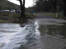


 - and it just didn't end. I was amazed that i did not bin the vstrom...but i had numerous bucking bronco "oh fuck" moments where by the grace of god I got through a mess still upright...what I would have given for a smaller/lighter dualsport!!! Double kudos to some of the GS riders that were new to dirt...that was NOT noob friendly today...props for making it through - come back in the summer when its been packed down a bit by the 4wd trucks...it can really be nice ride on a big adv bike
  Fitting ending to a wild day.


