• There has been a recent cluster of spammers accessing BARFer accounts and posting spam. To safeguard your account, please consider changing your password. It would be even better to take the additional step of enabling 2 Factor Authentication (2FA) on your BARF account. Read more here.

Sierra Passes?

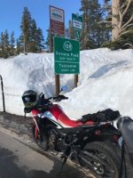
Monitor Pass opened about three weeks ago, but haven't been over it yet. Maybe tomorrow :teeth
The two track road (Leviathan Peak Lookout Rd) to Leviathan Peak is about 1/3 mile past the Summit on the left if your going East. I wouldn't recommend it on a street bike. Last time I was up there was two years ago in my Jeep. Nice views.

Have also been over Leviathan Mine Rd (about a 1 mile on left before Summit), dirt - 2 track in a lot of places, it takes you past the mine and East out to 395. Again, not street bike friendly. Leviathan Mine is an abandoned open-pit sulfur mine and on the Superfund cleanup list and you can't get down to it. You can see it from a couple of places as the road skirts around the South and East sides.
 
i mentioned 49 because it takes you (once it turnes east) from one side of the sierra to the other and is a twisty road.

yes, the pass it crosses in the sierra drains right back to where you started if you start in marysville and go east then turn onto 49.

highway 70 is in the same category, though i guess you'd say it doesn't cross any passes at all!

that's because the feather river (where 70 runs) cuts through the sierra.

doesn't mean it's not a twisty mountain road!
 
I just got back from the eastern Sierras. The only SIERRA pass open as of June 10th is 88. We got hit with rain and fog on Thursday. Saturday was gorgeous but today they're saying it may snow.
 
Last edited:
Conditions may have changes today with the storm that went though. I believe they got some snow:)
 
This highway information is the latest reported as of Tuesday, June 13, 2017 at 15:38 .

SR 108

[IN THE CENTRAL CALIFORNIA AREA & SIERRA NEVADA]
NO TRAFFIC RESTRICTIONS ARE REPORTED FOR THIS AREA.

Game on!
 
Sonora Pass, just the other day, compliments of my bro in law
 

Attachments

  • image.jpg
    image.jpg
    59.9 KB · Views: 56
Better do it soon, its melting fast

Nice photo! I want to get up there soon, too. That snow is awesome!

Did you drop down the back side of the pass with another AT on Saturday?


WoodsChick
 
Hi Tammy....Yeah that was me. Heres another from Saturday. Say hi to Dave.
 

Attachments

  • IMG_3719.jpg
    IMG_3719.jpg
    136.4 KB · Views: 41
Will be leading a group on hwy 88 - 89 - Pioneer Trail - 207 - 206 - Jacks Valley and want to be prepared. Anyone have any feedback?

What's the weather? Snow present? It will be warm until we get up to altitude correct? Thinking of bringing down jacket and balaclava to be safe.

Thinking of Sonora pass on the way back, what do you guys think?

Thanks!
 
lol, you can safely leave the down jacket at home. Just go to weather.gov and type in a few of the places along your route. The lowest temps you will see will be in the 70s on the summit. Still gonna be hot as balls every where else.
 
Bring layers. I did 88 a few weeks ago and I just had frog togs over my leathers, a fleece... And plastic bags over my socks because it was raining. Wasn't cold at all. And yes sweltering on the other side of the Sierras.
 
Don't worry about the mountain temps. Dress for the valley heat. Its a bit cooler in the mtns. Not cold by any means. I've been over Monitor to Virginia City for lunch a couple times in the last few weeks, the roads are clean and dry.
 
Don't worry about the mountain temps. Dress for the valley heat. Its a bit cooler in the mtns. Not cold by any means. I've been over Monitor to Virginia City for lunch a couple times in the last few weeks, the roads are clean and dry.

Nice. I'll be up in Carson Pass and Sonora Pass this w/e. :ride
 
Back
Top